ross sea semi-circumnavigation of antarctica

Ross Sea | Incl. helicopters

  • Overview
    This semi-circumnavigation of Antarctica has to be one of the most thrilling voyages on iExpedition. Only offered bi-annually you will need to be quick to secure your space on these voyages, as they are greatly anticipated voyages. Travelling with helicopters you'll explore regions of Antarctica seen by few. You'll also be one of few to explore both the East and West coasts of Antarctica, which are immensely different. As one recent guest on board describes this voyage - "This expedition had everything – jaw-dropping landscapes, whales galore, volcanoes, ice, ice and more ice of all kinds, berg, fast, sea, pancake, brash… forever sunsets, heroes, huts and of course, penguins….and I swear to God, the only thing missing was a unicorn" Mark Vogler. This voyage is now open for expressions of interest. Complete itinerary to follow in the coming weeks.
    Duration: 34 days
    Passengers: 116 passengers
    Embarkation Point: Ushuaia, Argentina
    Disembarkation Point: Invercargill, NZ
    Physical rating: Expedition
    Fly/Cruise: Cruise only
    Single Supplement: Unavailable
  • Itinerary
    • Day 1 - Ushuaia: Embarkation Day

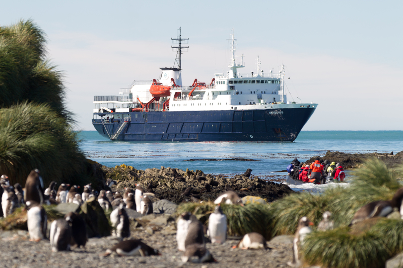
      Your voyage begins where the world drops off. Ushuaia, Argentina, reputed to be the southernmost city on the planet, is located on the far southern tip of South America. Starting in the afternoon, you embark from this small resort town on Tierra del Fuego, nicknamed “The End of the World,” and sail the mountain-fringed Beagle Channel for the remainder of the evening.

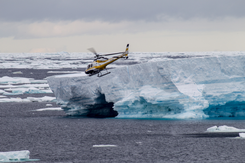
      PLEASE NOTE: All itineraries are for guidance only. Programs may vary depending on the local ice, weather, and wildlife conditions. The on-board expedition leader will determine the final itinerary. Flexibility is paramount for expedition cruises. The average cruising speed of m/v Ortelius is 10.5 knots. During these voyages, we transfer our passengers to shore using Zodiacs. We also operate our two helicopters at sites where Zodiacs cannot be used. Potential areas for helicopter transfer are Cape Evans (the location of Scott’s hut), Cape Royds (the location of Shackleton’s hut), the Ross Ice Shelf, Peter I Island, and the Dry Valleys. Our plan is to make five helicopter-based landings, though a specific amount of helicopter time cannot be guaranteed in advance. Helicopters provide us with a great advantage in reaching certain landing sites that are otherwise almost inaccessible, but this is a true expedition in the world’s most remote area: weather, ice, and other forces of nature dictate the final itinerary. Conditions may change rapidly, impacting helicopter operations. Please understand and accept this. Safety is our greatest concern, and no compromises can be made. The vessel is equipped with two helicopters. If one helicopter is unable to fly for whatever reason, helicopter operations will cease or be cancelled. One helicopter always needs to be supported by a second functioning helicopter. No guarantees can be given, and in no event will claims be accepted. Special note: Crossing the International Date Line Depending on which direction one travels across the International Date Line, a day is either lost or gained. (Crossing westward, a day is gained; crossing eastward, a day is lost.) Please take note of this when calculating your actual time travelled. The days listed in the itinerary duration reflect the actual time travelled.

    • Day 2/3 - Path of the polar explorers

      Over the next two days on the Drake Passage, you enjoy some of the same experiences encountered by the great polar explorers who first charted these regions: cool salt breezes, rolling seas, maybe even a fin whale spouting up sea spray.

      After passing the Antarctic Convergence – Antarctica’s natural boundary, formed when north-flowing cold waters collide with warmer sub-Antarctic seas – you are in the circum-Antarctic up welling zone. Not only does the marine life change, the avian life changes too. Wandering albatrosses, grey-headed albatrosses, black-browed albatrosses, light-mantled sooty albatrosses, cape pigeons, southern fulmars, Wilson’s storm petrels, blue petrels, and Antarctic petrels are a few of the birds you might see.

    • Day 4 - Through the Pendleton Straight

      You arrive at the Antarctic Peninsula near the Antarctic Circle in the afternoon. If sea ice allows it, you can then continue through Pendleton Strait and attempt a landing at the rarely visited southern tip of Renaud Island. Here you have the opportunity to see the first Adélie penguins of the trip as well as enjoy spectacular views of the icebergs in this surreal, snow-swept environment.

    • Day 5 - Sailing the Bellingshausen Sea

      From the peninsula you head toward the open sea, your course set for Peter I Island.

    • Day 7 - A rare glimpse of Peter I Island

      Known as Peter I Øy in Norwegian, this is an uninhabited volcanic island in the Bellingshausen Sea. It was discovered by Fabian von Bellingshausen in 1821 and named after Peter the Great of Russia. The island is claimed by Norway and considered its own territory, though it is rarely visited by passenger vessels due to its exposed nature. If weather and ice conditions allow, you may enjoy a helicopter landing on the glaciated northern part of the island. This is a unique chance to land on one of the most remote islands in the world.

    • Day 8/14 - Sights of the Amundsen Sea

      You then sail through the Amundsen Sea, moving along and through the outer fringes of the pack ice. Ice conditions are never the same from year to year, though we aim to take advantage of the opportunities that arise if sea ice is present. Emperor penguins, groups of seals lounging on the ice floes, orca and minke whales along the ice edge, and different species of fulmarine petrels are possible sights in this area.

    • Day 15/17 - The epic Ross Ice Shelf

      The next goal is to enter the Ross Sea from the east, venturing south toward the Bay of Whales and close to Roosevelt Island (named in 1934 by the American aviator Richard E. Byrd for President Franklin D. Roosevelt). The Bay of Whales is part of the Ross Ice Shelf, the largest ice shelf in the world, and is constantly changing with the receding ice masses. Large icebergs are present here, along with great wildlife opportunities. Roald Amundsen gained access to the shelf en route to the South Pole, which he reached on December 14, 1911. Also, the Japanese explore Nobu Shirase had his camp in this area in 1912, at Kainan Bay. You may make a helicopter landing on the ice shelf if conditions allow. During this part of the voyage, we will also cross the International Date Line.

    • Day 18/20 - Highlights of the Ross Sea

      Keeping to the Ross Sea, your aim is now to visit Ross Island. In this location you can see Mount Erebus, Mount Terror, and Mount Byrd, as well as many other famous spots that played an important role in the British expeditions of the last century: Cape Royds, where Ernest Shackleton’s cabin still stands; Cape Evans, where the cabin of Robert Falcon Scott can still be seen; and Hut Point, from which Scott and his men set out for the South Pole.

      If ice is blocking the way but weather conditions are favorable, you may use the helicopters to land in one or more spots in this area. The American scientific base of McMurdo Station and New Zealand’s Scott Base are other possible locations you might visit. From McMurdo Station you could also make a 10-km hike (6 miles) to Castle Rock, where there are great views across the Ross Ice Shelf toward the South Pole. Additionally, you may make a helicopter landing in Taylor Valley, one of the Dry Valleys, where conditions are closer to Mars than anywhere else on Earth.

    • Day 21/22 - Exploring the inexpressible

      Sailing north along the west coast of the Ross Sea, you pass the Drygalski Ice Tongue and Terra Nova Bay. If ice conditions allow, you then land at Inexpressible Island, which has a fascinating history in connection to the less-known Northern Party of Captain Scott’s expedition. It is also home to a large Adélie penguin rookery. Should sea ice prevent entry into Terra Nova Bay, you may head farther north to the protected area of Cape Hallett and its own Adélie rookery.

    • Day 23 - The residents of Cape Adare

      You next attempt a landing at Cape Adare, where for the first time humans wintered on the Antarctic Continent: The Norwegian Borchgrevink stayed in here 1899, taking shelter in a hut that to this day is surrounded by the largest colony of Adélie penguins in the world.

    • Day 24 - Ross Sea to the Southern Ocean

      Sailing through the sea ice at the entrance of the Ross Sea, you start your journey north through the Southern Ocean. The goal is to set a course for the Balleny Islands, depending on weather conditions.

    • Day 25 - The windswept Balleny Islands

      Your intended route is past Sturge Island in the afternoon, getting an impression of these windswept and remote islands before crossing the Antarctic Circle.

    • Day 26/28 - Sailing among the seabirds

      You once again enter the vast expanse of the Southern Ocean. Seabirds are prolific on this leg, during which we hope to enjoy good weather conditions.

    • Day 29 - Macca aka Macquarie Island

      Macca, also known as Macquarie Island, is a Tasmanian State Reserve that in 1997 became a World Heritage Site. The Australian Antarctic Division has its permanent base on this island, which Australian sealer Frederick Hasselborough discovered while searching for new sealing grounds. The fauna on Macquarie is fantastic, and there are colonies of king, gentoo, and southern rockhopper penguins – as well as almost one million breeding pairs of the endemic royal penguin. Elephant seals and various fur seal species, such as the New Zealand fur seal, are also present.

    • Day 30 - Northwest toward Campbell Island

      Heading northwest to Campbell Island, you’re once again followed by numerous seabirds.

    • Day 31 - Campbell Island’s bounteous birdlife

      The plan today is to visit the sub-Antarctic New Zealand Reserve and UNESCO World Heritage Site of Campbell Island, enjoying its luxuriantly blooming vegetation. The fauna on Campbell Island is also a highlight, with a large and easily accessible colony of southern royal albatrosses on the main island. Breeding on the satellite islands are wandering, Campbell, grey-headed, black-browed, and light-mantled albatrosses. There are also three breeding penguin species present: eastern rockhopper, erect-crested, and yellow-eyed penguins. In the 18th century, seals in the area were hunted to extinction, but the elephant seals, fur seals, and sea lions have since recovered.

    • Day 32 - Once more to the Southern Ocean

      Take in the vast horizons of your final sea day before you reach New Zealand.

    • Day 33 - Invercargill (Bluff); Disembarkation day

      Every adventure, no matter how sublime, must eventually come to an end. You disembark in Bluff, the southernmost town in New Zealand, and return home with memories that will accompany you wherever your next adventure lies.

    Please consider that our voyages are expeditionary in nature. This means, that there are no concrete itineraries, your Captain and Expedition Leader will utilise their vast experience to chart the best course for your expedition depending on the climatic and environmental conditions. Mentioned highlights and wildlife cannot be guaranteed.

  • Adventure Activities

    Helicopter Tours

    Helicopter tours offer you a perspective of Antarctica afforded to only a handful of explorers each season. This expedition will provide you with an entirely new perspective of this incredible continent as you fly in search of Emperor penguins.

    Included

    Whales

    Whale numbers swell in Antarctica over the southern summer. Arriving in Antarctica from November onwards, whale numbers reach their peak around December and January. Sightings and particularly breachings reach a pinnacle in February and March, when the Krill is closer to the surface. Some 10 species of whales are found in Antarctic water each summer, with the most abundant species being the Humpack.

    Adelie Penguins

    Adelie penguins are the most abundant of all penguin species and are there estimated to be some 5 million birds. They have been an incredibly successful species living further south than any other species and have one of the oldest continually used rookeries, which has existed for some 6,000 years.

    Shoot to your shutter's content!

    For aspiring photographers, the best time to shoot the Antarctic landscape is definitely October, November and March. At these times the sun is much lower in the sky and thus creates beautiful twilight hues and shadows, which contrast the landscape magnificently.

    Of course, if it is wildlife and Antarctica’s babies you are hoping to shoot, then January and February are the best times. Alternatively, consider an early season South Georgia & Antarctica expedition for the best of wildlife and photo opportunities in Antarctica.

    Cross the Antarctic Circle

    The moment you step foot into the circle, you’ll have a deep sense of wonder knowing you’ve just trodden where few have gone before. When you’re this far south, nature bares its secrets.

  • Inclusions
    Inclusions / Exclusions

    Included in your Expedition

    - Pre-departure information package
    - Expedition boots
    - All shore excursions and lectures in the itinerary
    - All accommodation and meals on board

    Not included in your Expedition

    - Expenses of personal nature including; Laundry / Bar / Beverages / Internet & Wifi
    - International and internal flights that are not specified
    - Pre and post-cruise accommodation
    - Government arrival and departure taxes
    - Mandatory waterproof gear not provided
    - Baggage / cancellation / interruption and medical travel insurance
    - Passport and Visa expenses
  • Map
    Screen shot 2017 11 10 at 11.55.01 am
  • Gallery
  • Vessel

    ORTELIUS

    “Ortelius” was built in Gdynia, Poland in 1989, was named “Marina Svetaeva”, and served as a special purpose vessel for the Russian Academy of Science. The vessel is re-flagged and renamed “Ortelius”. “Ortelius” is classed by Lloyd’s Register in London and flies the Cyprus flag. The vessel has the highest ice-class notation (UL1 equivalent to 1A) and is therefore very suitable to navigate in solid one-year sea ice and loose multi-year pack ice. “Ortelius” is a great expedition vessel for 116 passengers with lots of open-deck spaces. The vessel is manned by 22 highly experienced international nautical crew, 19 international hotel crew, 8 expedition staff (1 expedition leader, 1 assistant expedition leader and 6 guides/lecturers), and 1 doctor. Ortelius offers a comfortable hotel standard, with a u-shaped, a bar and a lecture room. Our voyages are primarily developed to offer our passengers a quality exploratory wildlife program, trying to spend as much time ashore as possible. As the number of passengers is limited to approximately 116 on the “Ortelius”, flexibility assures maximum wildlife opportunities. “Ortelius” carries 10 zodiacs. The zodiac engines are 60hp Yamaha.

    Features & Facilities
    • Comfotable hotel standard
    • Bar
    • Lecture Room
    • Spacious Observation Decks
    • Open Bridge
    • Helipad
    • Small gym
    • Internet/Wifi
    Key Facts
    Luxury star rating: 3
    Guests #: 116
    Crew #: 52
    Ice Class: 1A
    Speed: 12
    Refurbished:
    Technical Specs
    Year built:
    Length: 91m
    Width: 17
    Draft:
    Tonnage: 4575
    Registry: Cyprus
    Elec Outlets: 220V / 2 Round Pin
Check Voyage Dates, Pricing and Availability
All available dates
Ready to book your expedition?

We understand that the trip of a lifetime takes planning, so we make the financial commitments easy to manage.

  • Confirm your booking today with just USD$ 1,000 per passenger.
  • Pay your 25% deposit 5 day later.
  • Final payment due 120 days prior to departure.